




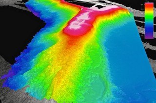
We are finally able to show you our first major survey area of leg two, which we have now completed.
Our target was an unusually shaped (and also quite large) volcanic ridge system toward the southeast side of the monument, which encompasses the French Frigate Shoals atoll along with the Brooks and St. Rogatien Banks. Although not yet officially named, we are calling what we have mapped Rogatien Ridge because West St. Rogatien Bank is the closest named feature.

The image to the right shows the multibeam coverage that we have been compiling over the years (in gray shades), and then the Falkor data overlain in color on the bottom. Before departure, we had just one swath of data along the axis of the ridge and a few perpendicular swaths. Once on site, we were able to generate a complete map (over several days) with much higher resolution than anything done before, and that, as you can see, covers a great deal more area.
Ancient Coral Cap
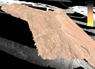
As for the ridge itself, it appears to be mostly volcanic with a carbonate, or fossil coral, cap. The cap is the flat and wide portion on top, presently at about 350 meters water depth. The carbonate continues down to the steep drop-off where the edge meets up with the older volcanic material about 1,200 meters down. Previous posts discussed similar flat bank tops.
Those cuts are especially clear in the backscatter images as dark streaks. We created the backscatter image using additional data from the sonar system
One of the most geologically interesting things about Rogatien Ridge is its size—about 100 kilometers long and 40 kilometers wide. This begs the question of why, in a chain of more isolated seamounts, banks, and atolls, is this feature so big? We hope analyzing all the data that we have collected will help us find an answer.
The ridge is also of biological interest because it may provide habitat for deep-sea corals and sponges that attach to hard substrate and, being filter feeders, thrive on steep topography with strong currents sweeping by.
Onward
We are now moving on to mapping another large feature, Gardner Pinnacles, near the middle of the monument. This feature is as large as Hawaii’s Big Island and is significant because it contains the last above-water exposure of volcanic rock. Only coral and sand islands exist farther to the northwest. We will keep making our way north where we left off on leg one, and then finish up work on the southern ends of Gardner and Rogatien on the way home.