




Dive In
About the Expedition
In search of an asteroid that ended the Cretaceous Period.
- Dive Markers
- Trackline
The Mission
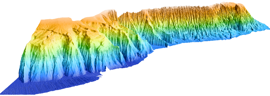
Campeche Escarpment is a prominent seafloor feature located off of the Yucutan Penninsula in the Gulf of Mexico that has never been investigated or mapped in detail.
However, the geological records that it contains may help us understand the circumstances of the very abrupt transition between the Cretaceous and Tertiary Eras (the K-T event) that took place approximately 65 million years ago and was accompanied by one of the most massive extinctions of life forms on our planet.
In collaboration with Monterey Bay Aquarium Research Institute researchers lead by Drs. Charles Paull, David Caress, and Roberto Gwiazda as well as Drs. Jaime Urrutia Fucugauchi from the Universidad Autonoma de Mexico and Mario Rebolledo Vieyra of the Centro de Investigacion Cientifica de Yucatan in Mexico, Schmidt Ocean Institute conducted the first surface multibeam mapping survey of the Campeche Escarpment aboard R/V Falkor. On this cruise live Falkor web cams were set to update every 10 minutes:Camera 1 - Control Room, Camera 2 A-Frame, Camera 3 - Aft Deck.
Team and Collaborators




Explore




Discover More
Expedition Data
Title  | Type | Repository |
|---|---|---|
| Bathymetry data | Sonar Data | National Centers for Environmental Information (NCEI) |
| Resulting bathymetric datasets from the multibeam mapping | Sonar Data | Marine Geoscience Data System (MGDS) |
| Vessel Underway data | Oceanographic Property Data | Rolling Deck to Repository (R2R) |
Publications from This Expedition
Paull, C.K. (2014). Preliminary Source Characterization and Tsunami Modeling of Submarine Landslides along the Yucatan Shelf/ Campeche Escarpment, southern Gulf of Mexico. Poster Presentation for American Geophysical Union Fall Meeting, San Francisco, CA, USA.
Paull, Charles K., David W. Caress, Roberto Gwiazda, Jaime Urrutia-Fucugauchi, Mario Rebolledo-Vieyra, Even Lundsten, Krystle Anderson, and Esther J. Sumner. 2014. Cretaceous – Paleogene boundary exposed: Campeche Escarpment, Gulf of Mexico. Marine Geology 392-400.
Chaytor, J.D., Geist, E.L., Paull, C.K., Caress, D.W., Gwiazda, R., Fucugauchi, J.U., and Vieyra, M.R. 2016. Source Characterization and Tsunami Modeling of Submarine Landslides Along the Yucatán Shelf/Campeche Escarpment, Southern Gulf of Mexico, Pure and Applied Geophysics, pp. 1–16, doi: 10.1007/s00024-016-1363-3.
McBee, J., Mitchell, G., Brumley, K., Gharib, J., and Paull, C., (2016). New Insights into the Campeche Escarpment Post-Chicxulub Impact Using Multibeam Echo Sounder (MBES) Bathymetry and Backscatter Data, Poster Presentation at American Geophysical Union Fall Meeting, San Francisco, CA, USA.